About Our Lake
Green Lake is the largest lake in the Chisago City area (1,810 acres). It has three distinct basins: the north end, which is commonly called Little Green, the large windswept main basin, and the southern end, which consists of shallow bays with abundant vegetation. Green and blue-green algae’s sometimes flourish in the summer creating the “green/blue” color. Green lake has great water clarity around 8-10 feet, and a maximum depth of 32ft.
The shoreline of Green Lake is very developed. It has approximately 335 homes and one regional park. The regional park located on Green Lake is Camp Ojiketa. This park is 70 acres of trees, trails, rental entertainment halls, and a few cabins. It is the newest and largest park in Chisago City. Ojiketa used to be a Camp Fire Girls camp, but is now a venue that can be rented out for weddings, family gatherings, or other events.
Green Lake supports a quality Northern Pike population, with an average length of 25 inches and fish in the mid-thirties present. Largemouth Bass are abundant with about one-quarter of adult bass 14 inches or longer. Requiring 6 to 7 years to reach a length of 12 inches, bass growth remains slow.
Black Crappie and Bluegill are the species most frequently caught by anglers on Green Lake, and abundance of both species is normal compared to similar lakes. Although some larger individuals are present, anglers will most often encounter 7-8 inch Black Crappies and 6 inch Bluegills.
Green Lake Aerial View

Map of Green Lake


Overview on Weirs
Info from Chisago County
Channel & Weir System
The Chisago Lakes Outlet Project was undertaken in 1986 to provide an outlet for the land-locked Chisago Chain of Lakes. The purpose of the project was to alleviate extremely high lake levels experienced in the early to mid-1980’s. Several property owners experienced damage from high lake levels during this time. To alleviate the high water situation, a plan was developed to create channels and build weirs (a small overflow dam used to alter the flow of water) to aid in controlling the flow of water throughout the lake system.
Lake System Water Flow
In general, the lake water flows through the Chisago Chain of Lakes, roughly, to the north from South Center Lake through a channel beneath Highway 8 to North Center Lake.
The Ditch and Weir System Map (PDF) and the Ditch and Weir Maintenance Map (PDF) shows the prominent flow areas for the Lake Improvement District. The flow arrows show the direction in which water flows through the lake system.
The water then flows from North Center Lake west through a channel to North Lindstrom Lake (beneath County Road 20), whereby it flows south into South Lindstrom Lake via a channel beneath Highway 8.
South Lindstrom Lake is connected to Chisago Lake; which has a weir on its north end adjacent to Paradise Park. If the water level is high enough to flow over this weir (a mattress weir, made of concrete blocks), then it will continue to flow northeast through a channel that flows into Wallmark Lake, eventually out-letting into a wetland northeast of Wallmark Lake.
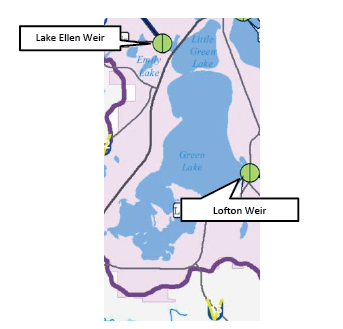
On the south end of Chisago Lake is a ditch or channel leading to a larger weir structure that controls the water flow into Green Lake. When the water levels are considered high, the gates within this weir are opened, allowing water to flow into Green Lake via a culvert beneath Lofton Avenue.
Out Through Sunrise River
The water in Green Lake flows north into Little Green Lake, and then continues north via a culvert under Highway 8 into Lake Ellen. There is a 3rd weir structure on the north side of Lake Ellen, similar in design to the weir structure that controls the flow from Chisago Lake to Green Lake. When the gates are opened in this weir, the water flows north through a long, underground pipe which outlets into Swamp Lake and eventually into the Sunrise River.


How does this whole “Weir” thing work?
- We have two weirs that can have a direct impact on water levels on Green Lake.
- The inlet (only water comes in) is on the south side of lake and is an inlet from Chisago Lake. It runs underneath Lofton Ave.
- The outlet (water can only leave) is on Lake Ellen, the inlet to lake Ellen runs under Hwy 8, and the weir is on the far end.
- The battle on the lake between who wants the water higher and who wants the water lower is always going to be on going, but the good thing is no one on the lake makes those decisions.
- The LID, or Lake Improvement District is in charge of controlling the weirs.
- Opening and Closing are determined be the water heights measured at fixed points on the lake.
- So when the Weir is open the lake must be draining? (typical question)
- No and Yes, may or may not be the answer??
- When a weir is open, does not mean that water is flowing into it. It is a large plate that goes up and down that allows the water to flow (or not to flow) into the drain.
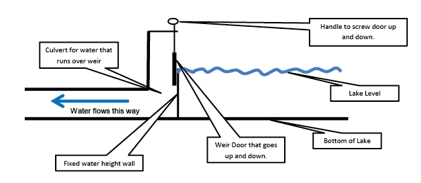
In the above picture there is a fixed water height wall. The lake water level would have to be above this in order to flow out into the culvert. The Weir door goes up and down, and is controlled by the handle on top of the weir. The drawing shows the weir door is open but water is not flowing, because the door is not low enough to let the water flow over the top of it. It is ready as the water height changes, but at this point the weir is open, and water is not flowing.
All in the weir is here to support the lake levels and prevent flooding. Overall the weir system is quite extensive and an engineering feet to have accomplished it all. You can check all about the entire weir system at the Chisago County website under Channel and Weir System for more information.
I hope this helps clarify how the weir works, and looking forward to a great summer